


 MENU
MENUWhat Is WaterCube?
WaterCube and Tecplot have joined forces to create a Water Resource Management Solution that helps scientists and researchers acquire, process and understand complex river-system data. We want to share this first-of-its-kind solution with you!
“Understanding What’s Happening in Your River Reach” will introduce you to a unique data visualization solution that takes the power of big data and makes it usable on a mass scale, allowing you to visualize, validate and manage river, reservoir and stream data.
In this Webinar, you’ll learn how the WaterCube/Tecplot solution can help you:
- Visualize and manage real 3D spatial river data like never before.
- Measure specific volumes of water and discharge at varying flows anywhere along the river reach, providing ideal locations for instrumentation placement and stream power.
- Calibrate computer-created predictive models for higher accuracy in flood and drought conditions.
- Perform advanced hydraulic analyses that determine sediment transfer, temperature changes, quality, and the impact to the environment.
Be among the first water resource professionals to learn about a more efficient and effective way to manage our most precious natural resource.
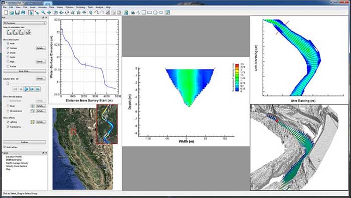
Cubeit Professional provides advanced capabilities for Analyzing 3D spatial river data and Digital Elevation Models (DEM’s) like never before. By utilizing the power of Cubeit Professional you can move down the river analyzing slope changes, velocity contour plots, bathymetry and 2D and 3D views of the area of interest.