


 MENU
MENULoad netCDF data with FVCOM loader, import georeferenced images and shapefiles, compute vertical transects
BELLEVUE, WA (October 17, 2018) – Tecplot, Inc. has announced the general availability of Tecplot 360 2018 Release 2.
This release will benefit geoscientists who work with results from numerical models such as FVCOM (Finite-Volume Community Ocean Model), ROMS (Regional Ocean Modeling System), WRF (Weather Research Forecasting Model) and Telemac (Loaders for ROMS, WRF and Telemac are available upon request, contact support@tecplot.com). Highlights that will benefit general Tecplot customers include new colormaps, handy Python scripts, updated Excel add-in, and a CONVERGE output file loader. See all of what is new.
“In our research [of the Geoscience market], we’ve found that most geoscientists spend an inordinate amount of time writing and modifying scripts to evaluate their simulation output,” says Scott Fowler, Tecplot 360 Product Manager. “We’ve also found that many with 3D model results are missing important features in their data because they use tools that do not easily support viewing and exploring the full 3D data.”
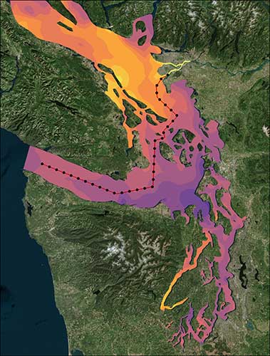
Georeferenced image of Puget Sound (Salish Sea) with vertical transect. Image created with Tecplot 360
Unlike script-based post-processing, Tecplot 360 allows geoscientists to quickly view and analyze full 3D models in an interactive user interface – without the need to write scripts. Tecplot 360 allows a quick and thorough exploration of XY, 2D and 3D results, which ensures that important information is neither missed nor overlooked.
Automation can speed analysis, and Tecplot 360 has a rich Python API known as PyTecplot. The Tecplot 360 Python API can generate images, movies and perform advanced analysis. Python scripts may be recorded based on user actions, which accelerates understanding of the API.
Unlike open-source solutions, Tecplot 360 comes with a responsive and knowledgeable Technical Support Team – reporting a 96.4% response time within one business day, and a 61.3% immediate response time.
Key features in this release for geoscientists are:
- FVCOM loader for netCDF data.
- ROMS, WRF, Telemac loaders available on request.
- Georeferenced image import to help communicate the location of your data (see video).
- Shapefile import to give additional context to the location of your data (see video).
- Vertical transect (curved slices) computation for vertically projecting a 2D plane along a prescribed path (see video).
- New colormaps for creating beautiful plots.
- Load-on-Demand technology for loading huge datasets.
Download Tecplot 360
Tecplot 360 2018 Release 2 is available for download as Free Trial Software, or for customers through the MyTecplot Customer Portal.
About Tecplot, Inc.
Tecplot, an operating company of Toronto-based Constellation Software, Inc. (CSI), is the leading independent developer of visualization and analysis software for engineers and scientists. CSI is a public company listed on the Toronto Stock Exchange (TSX:CSU). CSI acquires, manages and builds software businesses that provide mission-critical solutions in specific vertical markets.
Tecplot visualization and analysis software allows customers using desktop computers and laptops to quickly analyze and understand (local or remote) information hidden in complex data, and communicate their results to others via professional images and animations. The company’s products are used by more than 47,000 technical professionals around the world.
Contact:
More information: Tecplot 360
Contact: pr@tecplot.com